Mauna Loa - a Tempermental Mistress
Wednesday morning (2/6) Jamal, Kelly and I loaded up our 1980s Tahoe and made the long 4 hour drive up to Mauna Loa. Our plan was to stay there until Friday afternoon and work out the kinks of mine and Jamal's projects. We made it up the mountain in 4 hours and set up camp at the summit. We managed to find a relatively flat spot for our tent and arranged the car to block the wind. The tent sleeps 3 with no room for anything but our foam pads (2 each), sleeping bags (2 each) and water bottles (to avoid altitude sickness, even while sleeping). The sun sets around 6 pm and then the temperature drops drastically, reaching freezing and below. Our stove did not work, so we ate our precooked dinners in the car and then scrambled in to the tent as soon as it got dark. With nothing else to do, we "slept" from 7 pm to 8 am. Sleeping at that altitude is harder for 2 reasons: one, your body is struggling to adjust to 14000' and drinking water the entire time is imperative and two, the thinner air does not provide adequate carbon dioxide feedback and you wake yourself up gasping for air.

Eating in the car, facing Mauna Kea.

Before sunset on Wednesday, we managed to get a few hours of work in on my explosive fan deposit project. Below is a screen shot of my "mini computer" and the ArcPad screen complete with GPS tracking (plugged in a hand-held GPS) and unique data table. I was able to use the GPS to guide me through my grid (sample sites at 20m intervals) and then record the data straight in to a form on the computer. Jamal and Kelly were not so lucky and had to use the maps and excel sheets I created for them. The portion of the fan that we worked on is removed from the caldera edge and so had less explosive deposits to count, measure and record.
 Thursday morning we woke up with the sun, put on all the clothes we brought with us, filled up our water bottles with water and headed out to work on Jamal's project. Jamal is working with GPS and we first had to set up a base station to be constantly running and recording information while we took data at specified points. After setting it up, we drove 15 minutes down mountain to the summit trail, loaded up with batteries and the Leica GPS portable devices and made a quick 15 minute walk to Jagger's Cave at the edge of the caldera/Mokuaweoweo in an area called North Pit. Jagger was the leading volcanologist at the HVO during its early days and the museum is named after him.
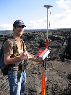
Jamal's project requires carrying the Leica GPS (see image below), a 10 lb battery and a hand-held GPS to find points in a grid similar to mine (but 300m between each sample area). The Leica GPS must always be carried near vertical to keep receiving signals from the satellite and is done easiest by hoisting the contraption over you shoulder. I went out alone and Jamal took Kelly to train her in the use of the device and correct assemblage and procedures. We had radios to stay in contact with each other as well as HVO in case of emergencies. Data collecting went rather smoothly for a hour until I fell through the pahoehoe (ropey basalt that has formed small tubes and bubbles) three times up to my knees. At this point I radioed Kelly and Jamal, told them I was heading back because my area was not safe, and booked it back to Jagger's cave.

We had heard from Frank via the radios that there were high wind warnings for the summit and that leaving early might be a smart and safe decision. High wind warnings include 30-45 mph winds with 60 mph wind gusts. At 3:30, after my mini flip out from falling through, we raced back to camp, took down everything, and headed off the mountain just as clouds and winds were rolling in. The below photo was taken during our descent and shows the disappearing peak of Hualalai, the third youngest volcano on the island. The next morning at work we find out there is a snow and ice warning for the summit of Mauna Loa with a continued high wind warning.
 Weather permitting, we will be back up on Mauna Loa this upcoming week, Tuesday-Thursday, to work solely on my project.

0 Comments:
Post a Comment
<< Home