i like it liquid hot: magma and me

Saturday, May 12, 2007

goodbye magma

Eight days ago I said goodbye to the Big Island and made the 24 hour trek back to sunny and warm NC. Before I could leave, I wrote my final report and analysis of the explosive deposit -- including my estimation of where the eruption originated from. On my last day, Frank showed me a powerpoint presentation of his own rough take on the eruption site and we matched! My research solidified some points he was speculating to be true as well as showed some interesting trends that will force him to rethink his own analysis. In the long run, Frank plans on publishing an article on the eruption and my data will be used in his paper, i.e., I get published!

The house was being inundated with 4 new volunteers, so it was perfect timing for me to hit the road and begin the next stage of my life. My experience in Hawaii pushed me physically and mentally in ways I had never experienced and although it had its ups and downs, I would not change it. I learned life skills (driving a manual, changing a tire), camping skills (yes, 2 sleepings bags are necessary at 14,000') and enhanced my geological knowledge (I saw a volcano in action!).

Mahalo!

Saturday, April 14, 2007

beach party!

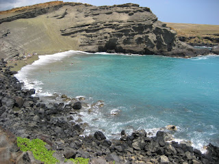
Two weekends ago, Jamal, Tyler, Brendan and I headed out along with south portion of the island with two goals: the black sand beach at Punalu'u and the green sand beach at South point.

particular bakery makes malasadas (pastry with filling, burger style) that come with a variety of fillings - chocolate and vanilla pudding, fruit jam and special Hawaiian seasonings. Sufficiently stuffed, we made our way to South Point and ventured on to a 3-mile stretch of road, accessible only by 4-wheelThe black sand beach is located about a 45 minute drive south of the park and is a camping, picnicking and beach lounging spot. It is also a popular place to spot turtles although we saw none while there. It was a quick stop and then back in the car, on our way to a famous bakery. This drive vehicles. When I say road, I actually mean a collection of roads branching out and reconnecting, like a braided river, all over the coast line -- navigating was tricky but exciting. The green sands beach is composed of almost pure olivine - a green mineral that is the first to crystallize as magma cools. In this particular place, erosion rates and tidal patterns managed to form a beach that is 70% olivine. A downside to this spectacularly beautiful place is that the mineral absorbed more heat then normal beaches and so walking on it was painful. We got in the water first so that our beach towels would be slightly wet and allow us to sit/lay on them without baking.


The following weekend we had the opportunity to stay in a beach house along the west coast, near Kona, in an area known as Puako. Vicki, a 40ish "volunteer" who works for Frank (and shares our tiny office) is caretaker for a house and invites Frank there every couple of weekends to stay and enjoy the beach. This particular weekend we, the 6 volunteers, had the fortune to tag along and experience this section of the island. The yard was massive, a dream for children and dogs, and included mango, lime and banana trees. The main house contained 2 bedrooms and an open kitchen with living room; the showers were located outside but were private and equipped with hot water. Frank and his wife, Zoe, stayed in the guest house along with their dog Pepe.


Upon arrival, Frank pulled out 5 sea kayaks from his car and under the house! Tyler, Kelly and I jumped at the chance to go whale watching and we ventured out past the coral reef cove and in to the open ocean. The water was choppy and it was insanely windy, so we paddled as hard as we could for 30 minutes before turning the kayaks to face the open sea. At this juncture, we all sat in our boats and looked for breaching whales. The water was a perfect blue, like you see in Disney World on water rides, and although I was soaked from the waves, I was not cold. Kelly capsized from a large wave but managed to get back on after a frantic, but funny, 5 minutes.


That night, the 10 of us staying at the house started an epic game of crochet while Frank smoked chicken smothered in Hawaiian spices. After a rocky start by the volunteers, we managed to catch up and play a competitive game for about 2 hours. Frank's rule was that if you are playing, you had to be drinking -- good thing he brought 2 coolers of his own homebrew beer. After dinner he opened up a bottle of his fruity champagne, 2004, and we toasted the good weather and his victory at crochet.

Sunday was more sea kayaking, beach hiking, petroglyph viewing, and my domination of a 500 piece puzzle in 4 hours. Pepe and I had a full on collision while playing catch with the football with Jamal -- apparently Pepe has not learned how to avoid hitting people. In an attempt to dodge the speeding dog, I stepped the wrong way and his head slammed in to my leg, leaving an impressive 5 inch bruise and a woozy dog. I think I won.

Monday, April 02, 2007

pu'u o'o is smokin!

An integral part of HVO's work involves monitoring the lava flows, ocean entries and vent of Pu'u O'o -- the active part of Kilauea. Lava is no longer erupting from the crater, but has moved down the fault line to the southeast. The fault line is spotted with old craters and vents from previous eruptions, but has been erupting at Pu'u O'o since 1983. Every other week, Tim, the main Kilauea physical volcanologist on staff (and Tyler's supervisor) flies out in a hired helicopter to photograph the flows and vent to determine where the current breakouts are and keep an eye on the vent and its structure at Pu'u O'o. Every volunteer is guaranteed at least one helicopter ride and my card came up this past Thursday.

I was accompanied by Brendan, a short term volunteer, on our helicopter journey. We got all decked out in military green flight suits and huge flight helmets and gave ourselves flight names (Nene - a bird here, and Ohelo - the berry they eat). Our helicopter has the doors removed so Tim can get better pictures as well as allow for more gear to be carried. We headed out to the coast line via a seismic station that needed a new battery and a quick jaunt over Pu'u O'o to determine the best landing site. At the coast line, David, the pilot, flew over the ocean entries and then back towards the pali (cliff/hill) to search for the highest breakout of lava location. Lava travels from Pu'u O'o in lava tubes and then breaks out along the pali and down at the coast. Breakouts can occur almost anywhere along the tubes, so every week Tim samples lava from different locations. Sampling involves finding an active break out, smashing at the red, viscous lava (its like really thick maple syrup) with his hammer and depositing the sample instantly in to tin can filled with water. This instantly quenches the lava and allows him to analyze the exact chemical composition of the lava before it starts to partially crystallize.

After sampling, we got back in the helicopter and went back up the pali to the vent. David dropped us off with promises to return in 2.5 hours to pick us up. Our mission for the day was to remove a camera located in a precarious spot, photo-document the vent and any new rock, replace a tripod for one of the main cameras and collect Pele's tears (tiny pieces of basaltic/lava glass that few out of the vent and form in teardrop shapes). Tim was careful to keep an eye on Brendan and I as well as inform us of what was newly formed rock. My favorite moments were when we walked over an active lava tube that was smoking and had a lava break out 5m away the past week and then later, when the vog was so thick that you could not see 3m in front of you. We did a full loop around the vent before returning to wait for the helicopter.

The highlight of the trip was when we got to peer in to East Pond Vent. As we approached, it sounded like we were walking up to the ocean during a violent and raging storm. Careful not to get too close to the edge, we looked over and saw an active lava lake! The surface was 20m down and bright red with lava slamming against the walls. Part of the surface had already cooled and turned to black basalt, but we had a perfect angle to see the deep red fly around.

Now I will post about 1/4938 of the photos Brendan and I took, combined.

Later this week I will ride in the helicopter again, but this time around the summit of Mauna Loa. Up there, the helicopter can only hold one passenger because the air is so thin!


Ohhhh yeah. Top gun?


Elliptical shape in top right is a shatter ring -- it inflates and deflates with lava and gas. This is the current ledge; the darker grey is the current flow spilling over the edge.


Close up of ocean entry. Last week park rangers had to remove a couple who were camping on the beach . . . I cannot even comment on it.

Our helicopter waiting on the lava flows while we get a sample.


Tim in his full body protection suit collecting a red hot sample with his trusty Maxwell House Coffee can waiting with water.


Two of the three entries.

A road to nowhere.

Royal gardens on fire.

Pu'u O'o! The gas does not smell good, makes you cough and your eyes run. Gas masks and sunglasses are a must.


I am sooo cool. That suit does not breathe well.


Hmmm, something tells me this equipment no longer works.


Tim on a mission to get some photos. The low level steam is coming from an active tube that we will later walk over -- 5 m from a skylight (open top of tube).


The lava right below the steam is a new breakout! It is rare to find a surface flow near Pu'u O'o.


Trekking in to the vog and unknown. Yeah, I did a perfect slide in to 3rd base during this walk.


Recording some data as Tim takes the alignment and measurements of the camera.

The most amazing sight ever -- lava lake!
Saturday, March 24, 2007

i feel . . . cold

Similar to Captain Barbosa, one does not physically feel sensations when camping on Mauna Loa. The overwhelming feeling is fatigue but hunger and thirst do not register. There is no desire to eat or drink but you are reminded of the need to when your body starts to give out. For someone like myself who loves eating, this sensation is unexpected and surprising.

We headed up at 5 am on Tuesday, arriving at our campsite at 9 am after being delayed by a hospital helicopter picking up a patient after an accident at 7 am. In an effort to finish Jamal's GPS mapping project, the summit caldera was separated in to a 300 m grid plus 3 East-West lines at 100 m points. What this means is that at every 300 and 100 m mark, we use the GPS to take a 2 minute survey reading of the elevation and exact longitude and latitude. Jamal can then compare the numbers to previous surveys to see if the caldera is deforming as well as analyze Frank's theory regarding the location of the shallow magma chamber and feeder dike.

The caldera is about 5 km long and 2 km wide and takes ~ 2 hours to hike at a steady rate. Tuesday we hiked out about 3/4 of the way and collected data until around 4 pm. Kelly and I were back in the SW corner and basically had to sprint hike back to get to camp before the sunset. Wednesday was a much more rigorous hiking day, since we were surveying the far end of the caldera and started hiking at 8:30 am. Wednesday the three of us walked all over the entire caldera and found a plethora of goodies - bagel, light bulb, dead bird, dead bug, old surveying equipment, glasses.

The combined weight of backpack containing water, food, rain jacket, first aid kit, walkie talkie, extra batteries, GPS battery plus the GPS unit is around 25-30 lbs. Carrying the GPS is awkward and I have bruises on my shoulders, chest and have a spot on my neck that was rubbed raw. I was fortunate enough to stay on my feet the whole time, but Kelly and Jamal both fell down in the a`a` and fell through the pahoehoe, up to their waists at times. Overall, we hiked ~17 miles and managed to finish Jamal's project. The weather was so beautiful on Wednesday that when we finished at 2:30, we took our time hiking back and enjoyed mini-naps in the sun every km.

Spatter ramparts! We camped near some red ones along the trail. They stretch out NE from the 1940 cone.

Jamal on the trek to find his GPS battery. The battery weighs ~10 lbs, so we left them in the middle of the caldera overnight to save our backs.

Standing on a collapsed slope in the SW corner of the caldera. Our camp is located at the NE tip. Do not want to be around when those huge chunks of wall come crashing down. Here is a google map link to the summit of Mauna Loa.


Ooohh. I am pressing start. In two minutes, I will press stop. The device has a leveling bubble that needs to be centered using the orange bipod legs.

A fissure! It was rather smelly - fumes of volcanic gases are unpleasant. Speaking of, last week we had dangerous levels of carbon dioxide and SO2 at the Observatory, so our lungs were tested for CO2 output. All of the interns tested as "heavy smokers"! Not good.


Tilted shot of the collapsed slope and wall. Facing South.

Friday, March 09, 2007

action shots!

Taking gas samples in Halemaomao, the crater of Kilauea. Measured CO2 plus temperature - around 90 C! Gas masks are essential to avoid the "vog" but the temperatures are so hot that you start to sweat inside. Gross

All of my Mauna Loa gear - GPS, walkie talkie, giant palm pilot, really cool hat and 10' water hose. Getting anything out of my backpack is an ordeal.


Entering data! Although having the palm pilot makes recording data in the office easier, it has become a pain in the field. Batteries have limited life (~ 3 hours) plus more than once all my data has been randomly erased.

So I lost the pointy end of my bipods of the GPS unit in the middle of Mokua`weo`weo, caldera of Mauna Loa - black on black, almost impossible to find. Kelly and I hiked out the next day and searched a 600 m traverse to find them. I was giving up hope and started to imagine how much trouble I would be in (replacing them would cost hundreds) when I basically tripped over the pieces! Phew, disaster avoided.

Our new campsite - right in the middle of the road. The road is gated and only available to HVO staff, so we do not have to worry about blocking any traffic since we are the only people who drive up. Our truck, Frank the Tank (named after our boss and Old School) is such a beast that when driving down the mountain Kelly did not use any gas for half the trip. The 4-wheel drive is so powerful that it just pulls itself up the hills.

Friday, March 02, 2007

the most hilariously bad Mauna Loa trip

Last week (2/21 - 2/23) the three of us headed back up to Mauna Loa to try to finish off the data collection stage of my project. We had 13 field areas to cover and feared that the weather would not hold and come sweeping in from the SW to cover us in fog and rain.

Within the first few hours, things started to go downhill. Kelly and Jamal each have a hand-held GPS unit with the grid coordinates already uploaded and labeled so they can just click "go to" and get the bearing and distance to their next point. Kelly was the first to notice that instead of her distance to walk being 20 - 100 m, it was around 7368374 km. Turns out the points had not been "projected" within the correct global units and were plotting, basically, in random space. My palm pilot had the correct points on it, so I was able to give them the correct coordinates and they could manually enter the points. This, unfortunately, sapped my battery power and required us to stay up late in the tent typing in numbers. A`a` on the left and pahoehoe on the right


The next morning, after sleeping in -4 C, was crisp and clear and we headed up to the summit, with well wishes of "Happy Counting!". I managed to walk directly in to a hole and twist my ankle. Despite my best efforts, I managed to fall over like a lumbering rhinoceros with all my gear flailing behind me. Basically, hiking on pahoehoe and a`a` is like using a stairmaster, so an ankle injury makes one almost useless. I hiked on it for about 4 hours, stopping once to get an ACE wrap from Kelly, until lunch time. Lunch came conveniently when all 3 of my spare batteries for the palm pilot died and I finished the last point in my field area. During a lunch time conference (hmm, cold soup), we decided that I would go pack up the car while they did another field area and then head home early.

My cankle! groovy


When I was about 100 m from the car, I noticed that our tent was not where we left it this morning. Instead of zipping up the doors, we had left them wide open, giving the wind a perfect opportunity to steal it. I located it quite a distance downhill, upside down, with all the sleeping bags (5 of them), ipod and speakers, littered on the ground. Took me some fancy maneuvering and careful placement of rocks, to prevent the tent from blowing away again, before everything was put back in their place and the car packed. At this point I radioed Kelly and Jamal to tell them the car was packed and that a blanket of fog was approaching from the saddle between Mauna Loa and Mauna Kea. Kelly then informed me that she could no longer see the car and that they were heading back now before it got too bad.

The prefect end to our camping trip gone awry came as we drove down in a hail storm. Yes, HAIL, for 40 minutes, in Hawaii. What?

This week has been spent in the office since its snowing and foggy on the summit but next week we are starting the first stage of Jamal's GPS project.

Tuesday, February 20, 2007

wait, there is more to Hawaii than rocks?!

A little Hawaiian photo shoot

Akaka Falls ~ 800'


Sunset from Mauna Loa. To the east, the shadow of the mountain is so large it is dubbed, the "100 mile shadow".


Sea Turtle! Lassoed some Sea Turtles and latched them together with hair from my back.


Mauna Loa in the morning from Beach 67 near Kona, west side of the island


Right: Ginormous trees - I felt like I was on Lost


Below: Sunset from beach 67 - saw some whales playing and turtles wading