i feel . . . cold
Similar to Captain Barbosa, one does not physically feel sensations when camping on Mauna Loa. The overwhelming feeling is fatigue but hunger and thirst do not register. There is no desire to eat or drink but you are reminded of the need to when your body starts to give out. For someone like myself who loves eating, this sensation is unexpected and surprising.
We headed up at 5 am on Tuesday, arriving at our campsite at 9 am after being delayed by a hospital helicopter picking up a patient after an accident at 7 am. In an effort to finish Jamal's GPS mapping project, the summit caldera was separated in to a 300 m grid plus 3 East-West lines at 100 m points. What this means is that at every 300 and 100 m mark, we use the GPS to take a 2 minute survey reading of the elevation and exact longitude and latitude. Jamal can then compare the numbers to previous surveys to see if the caldera is deforming as well as analyze Frank's theory regarding the location of the shallow magma chamber and feeder dike.
The caldera is about 5 km long and 2 km wide and takes ~ 2 hours to hike at a steady rate. Tuesday we hiked out about 3/4 of the way and collected data until around 4 pm. Kelly and I were back in the SW corner and basically had to sprint hike back to get to camp before the sunset. Wednesday was a much more rigorous hiking day, since we were surveying the far end of the caldera and started hiking at 8:30 am. Wednesday the three of us walked all over the entire caldera and found a plethora of goodies - bagel, light bulb, dead bird, dead bug, old surveying equipment, glasses.
The combined weight of backpack containing water, food, rain jacket, first aid kit, walkie talkie, extra batteries, GPS battery plus the GPS unit is around 25-30 lbs. Carrying the GPS is awkward and I have bruises on my shoulders, chest and have a spot on my neck that was rubbed raw. I was fortunate enough to stay on my feet the whole time, but Kelly and Jamal both fell down in the a`a` and fell through the pahoehoe, up to their waists at times. Overall, we hiked ~17 miles and managed to finish Jamal's project. The weather was so beautiful on Wednesday that when we finished at 2:30, we took our time hiking back and enjoyed mini-naps in the sun every km.
 Spatter ramparts! We camped near some red ones along the trail. They stretch out NE from the 1940 cone.
 Jamal on the trek to find his GPS battery. The battery weighs ~10 lbs, so we left them in the middle of the caldera overnight to save our backs.
 Standing on a collapsed slope in the SW corner of the caldera. Our camp is located at the NE tip. Do not want to be around when those huge chunks of wall come crashing down. Here is a google map link to the summit of Mauna Loa.
 Ooohh. I am pressing start. In two minutes, I will press stop. The device has a leveling bubble that needs to be centered using the orange bipod legs.
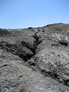
 A fissure! It was rather smelly - fumes of volcanic gases are unpleasant. Speaking of, last week we had dangerous levels of carbon dioxide and SO2 at the Observatory, so our lungs were tested for CO2 output. All of the interns tested as "heavy smokers"! Not good.
Tilted shot of the collapsed slope and wall. Facing South.

1 Comments:
volcano pirate?
Post a Comment
<< Home