i like it liquid hot: magma and me

Tuesday, February 20, 2007

wait, there is more to Hawaii than rocks?!

A little Hawaiian photo shoot

Akaka Falls ~ 800'


Sunset from Mauna Loa. To the east, the shadow of the mountain is so large it is dubbed, the "100 mile shadow".


Sea Turtle! Lassoed some Sea Turtles and latched them together with hair from my back.


Mauna Loa in the morning from Beach 67 near Kona, west side of the island


Right: Ginormous trees - I felt like I was on Lost


Below: Sunset from beach 67 - saw some whales playing and turtles wading

Saturday, February 17, 2007

lava is pretty

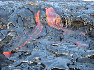
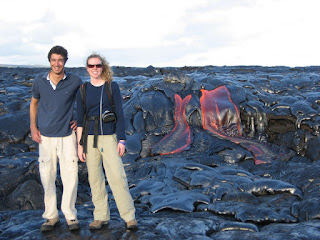
This past Sunday (2/11) Tyler, Jamal, Emma, Loren (computer geek at HVO) and I went out late afternoon/early evening to the Kilauea lava flows. Tyler's job/internship at HVO is to go out in to the lava flows 2-3 times a week to map the current eruptions, so he was able to take us directly to active flows. It was about a hour hike out to the flows and then blam! We could see the heat shimmer off the flows and with strong winds, it felt like we were in a huge hair dryer. The steam vents were rather active, so we had to watch where we stood to avoid inhaling toxic fumes. We got lucky and saw a small lava fall break out. Long sleeves and pants are recommended when standing close to the lava - I learned that the hard way when my arm hair was singed while video taping some lava.

Earlier that day, Emma and I went to Macy's to buy new lava flow pants because we both had inappropriate pairs. Mine were made of synthetic materials and hers were ripped. My new cotton/linen pants would not flash melt to my body if I got too close to the lava!


We crossed over a "cooled" section of the lava tube to see what was happening on the other side, which is always an exciting and risky adventure. You judge the relative age and temperature of tubes by their color - the more silver it is, the less stable it is to walk on. Even with the "stable" sections, we could see red lava in the cracks 2' below our feet. At one point Tyler (the leader) called a retreat and we carefully backtracked to safety.
For videos of lava, go on to YouTube and search for "kaitlin lava". The videos are processing, so cross your fingers that it works!

Sunday, February 11, 2007

Mauna Loa - a Tempermental Mistress

Wednesday morning (2/6) Jamal, Kelly and I loaded up our 1980s Tahoe and made the long 4 hour drive up to Mauna Loa. Our plan was to stay there until Friday afternoon and work out the kinks of mine and Jamal's projects. We made it up the mountain in 4 hours and set up camp at the summit. We managed to find a relatively flat spot for our tent and arranged the car to block the wind. The tent sleeps 3 with no room for anything but our foam pads (2 each), sleeping bags (2 each) and water bottles (to avoid altitude sickness, even while sleeping). The sun sets around 6 pm and then the temperature drops drastically, reaching freezing and below. Our stove did not work, so we ate our precooked dinners in the car and then scrambled in to the tent as soon as it got dark. With nothing else to do, we "slept" from 7 pm to 8 am. Sleeping at that altitude is harder for 2 reasons: one, your body is struggling to adjust to 14000' and drinking water the entire time is imperative and two, the thinner air does not provide adequate carbon dioxide feedback and you wake yourself up gasping for air.


Eating in the car, facing Mauna Kea.
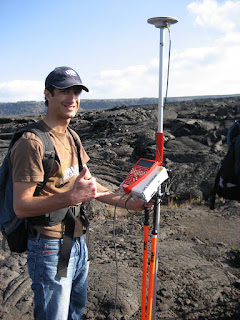
Before sunset on Wednesday, we managed to get a few hours of work in on my explosive fan deposit project. Below is a screen shot of my "mini computer" and the ArcPad screen complete with GPS tracking (plugged in a hand-held GPS) and unique data table. I was able to use the GPS to guide me through my grid (sample sites at 20m intervals) and then record the data straight in to a form on the computer. Jamal and Kelly were not so lucky and had to use the maps and excel sheets I created for them. The portion of the fan that we worked on is removed from the caldera edge and so had less explosive deposits to count, measure and record. Thursday morning we woke up with the sun, put on all the clothes we brought with us, filled up our water bottles with water and headed out to work on Jamal's project. Jamal is working with GPS and we first had to set up a base station to be constantly running and recording information while we took data at specified points. After setting it up, we drove 15 minutes down mountain to the summit trail, loaded up with batteries and the Leica GPS portable devices and made a quick 15 minute walk to Jagger's Cave at the edge of the caldera/Mokuaweoweo in an area called North Pit. Jagger was the leading volcanologist at the HVO during its early days and the museum is named after him.

Jamal's project requires carrying the Leica GPS (see image below), a 10 lb battery and a hand-held GPS to find points in a grid similar to mine (but 300m between each sample area). The Leica GPS must always be carried near vertical to keep receiving signals from the satellite and is done easiest by hoisting the contraption over you shoulder. I went out alone and Jamal took Kelly to train her in the use of the device and correct assemblage and procedures. We had radios to stay in contact with each other as well as HVO in case of emergencies. Data collecting went rather smoothly for a hour until I fell through the pahoehoe (ropey basalt that has formed small tubes and bubbles) three times up to my knees. At this point I radioed Kelly and Jamal, told them I was heading back because my area was not safe, and booked it back to Jagger's cave.
We had heard from Frank via the radios that there were high wind warnings for the summit and that leaving early might be a smart and safe decision. High wind warnings include 30-45 mph winds with 60 mph wind gusts. At 3:30, after my mini flip out from falling through, we raced back to camp, took down everything, and headed off the mountain just as clouds and winds were rolling in. The below photo was taken during our descent and shows the disappearing peak of Hualalai, the third youngest volcano on the island. The next morning at work we find out there is a snow and ice warning for the summit of Mauna Loa with a continued high wind warning. Weather permitting, we will be back up on Mauna Loa this upcoming week, Tuesday-Thursday, to work solely on my project.

Monday, February 05, 2007

Random Rock Week

At the end of last week, Andy, Jamal, Emma and I went in to Kilauea caldera to take GPS measurements of elevation changes in the caldera. It was the final training session for Jamal and I to learn how to use the Leica GPS unit and process the data with Leica Geo Office before Andy returned to London. The GPS unit is rather awkward to carry plus a 10 lb battery - makes for quite a sweaty excursion. The Observatory threw a little party for Andy at the end of the week and we took him out for breakfast on Sunday at the Volcano House breakfast buffet.

This week Jamal and I made the official decision on which project we wanted. Jamal is point man on a GPS project to record elevation measurements on the floor of Mokuaveoveo (caldera of Mauna Loa) and I am taking the lead on mapping an explosive fan deposit at the summit of Mauna Loa. The better part of my week was spent reading the user manuals for ArcView GIS, ArcPad and DNR Gamin and familiarizing myself with the programs. On ArcView I am making maps of my work area using GridMaker and topographic maps. The field area is 1x1 kilometers and I divided it in to 20 m sided squares. At each corner of a square plus the point in the middle I will be taking data within a 1 meter radius. The data I am collecting includes number of explosive rocks, types of explosive rocks and size of the 3 largest rocks. Explosive deposits include 5 types: ponded lava, weathered ponded lava, vesicular pahoehoe, weathered red pahoehoe and gabbro. The size of the 3 largest rocks are recorded to determine the energy required to project them that far and hopefully the mechanism behind the eruption. Using an Advantech CE device (hand held computer) loaded with ArcPad, I have created a table to imput data directly while in the field. The DNR Gamin is a hand held GPS device that has the grid points loaded in to it and can take me directly to the coordinates. Jamal and Kelly will be helping me in the field and be using their own GPS device but have to record the data with paper and pencil.

The only car capable of driving us up to Mauna Loa is a manual transmission, so this week Jamal and I had our first lesson on a 2002 Blazer around the Kilauea caldera. It was a rather jerky ride plus some stalling incidents for the both of us, but we managed without incident (except for that chicken I almost plowed over). That same day Emma took us with her on her gas sampling trip. We hiked 20 minutes to the western part of the Kilauea caldera along the rim of Halemaumau. She measures the carbon dioxide levels of fumaroles as well as the temperature of the steam and the water level. It was a particularly stinky afternoon, so during most of our hike we wore our gas masks. The temperature in the fumaroles was around 91 C and fogged up my sunglasses while I was taking samples.

Today (Sunday) Emma and I went on a 4 mile hike around Kilauea Iki caldera. In 1959 a half mile fissure erupted along the caldera wall of Kilauea. It erupted for 5 weeks from 17 different vents and created an isolated lava lake - a total of 86 million tons of lava. The lava was 2200 F and the hottest lava ever measured on the volcano. When lava drained from the caldera, the surface of the lake dropped 50' and created a "bath tub ring" around the edge. Steam still rises out of the caldera and deposits calcium sulfates and silica on the floor. A tumulus forms when pressure/magma beneath the crust pushes up and forces the crust to pop like a bubble.


Jungle walk at the beginning. Don't walk off the path because crevasses and steam vents are hiding in the vegetation. Pu`u Puai, main vent for the eruption.
Basalt with olivine crystals! Green mineral in the bottom left.
Tumulus! Don't want to be standing on that when it popped!

Steam vents makes the caldera look as if it just cooled.

On the lighter side of life, we took a trip in to Hilo on Saturday for a sushi lunch and explored the Japanese garden located in the bay. The local grocery store, KTA, has delicious poke - raw fish, usually marlin or tuna, marinated in a variety of flavors. I recently purchased black bean marlin and it is chewy and spicy snack. Another volunteer house is populated by students from a school in Germany and they had a gathering on Saturday evening. A dance party broke out and Tyler and I showed off our famous fishing dance plus our newly minted one - flossing.

Next week: Jamal, Kelly and I spend 2 nights at the summit of Mauna Loa. Below freezing evenings, sleeping on uneven lava, spectacular star views, precooked food and our first attempt at taking data!